Property Record
10461 Courthouse Rd, Spotsylvania, VA 22553

NEARBY LISTINGS FOR SALE OR LEASE
Property Detail
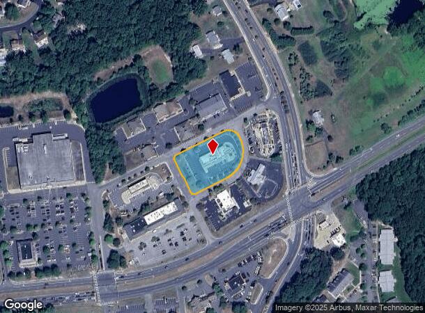
10461 Courthouse Rd
35-6-6
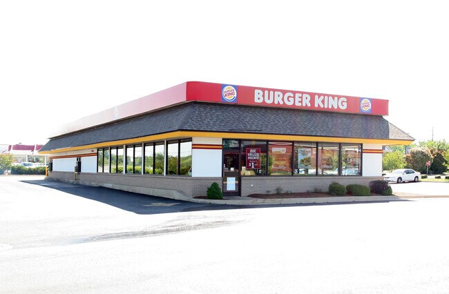
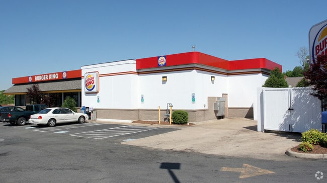
Hilltop Center
Commercialnec
BURGER KING #9370 RT 208639 PARCEL 6
X
Spotsylvania
51177C0225D
Virginia
2025
1.21 AC
2025
Spotsylvania County
020307
Washington, DC
4,334 SF
Washington-Arlington-Alexandria, DC-VA-MD-WV
DEMOGRAPHICS near 10461 Courthouse Rd
1 Mile
3 Mile
5 Mile
2024 Total Population
10,147
59,934
115,118
2029 Population
11,211
66,398
126,849
Pop Growth 2024-2029
+ 10.49%
+ 10.79%
+ 10.19%
Average Age
38
38
38
2024 Total Households
3,853
21,657
41,333
HH Growth 2024-2029
+ 10.62%
+ 10.97%
+ 10.35%
Median Household Inc
$84,561
$97,431
$94,910
Avg Household Size
2.60
2.70
2.70
2024 Avg HH Vehicles
2.00
2.00
2.00
Median Home Value
$310,222
$337,752
$344,398
Median Year Built
1988
1995
1995
Nearby Places
Map Layers
Map Styles
 Street
 Aerial
- Restaurants
- Banks
- Shops
- Fitness
- Groceries
PUBLIC TRANSPORTATION
COMMUTER RAIL
Fredericksburg (Fredericksburg Line - Virginia Railway Express)
DRIVE
WALK
Distance
Fredericksburg (Fredericksburg Line - Virginia Railway Express)
13 min
6.0 mi
Spotsylvania (Fredericksburg Line - Virginia Railway Express)
DRIVE
WALK
Distance
Spotsylvania (Fredericksburg Line - Virginia Railway Express)
16 min
7.4 mi
Freight Ports
Virginia Port Authority - Richmond
DRIVE
WALK
Distance
Virginia Port Authority - Richmond
75 min
60.4 mi
SALE & LEASE HISTORY
LISTING DATE
SALE/LEASE

Sep 23, 2016
For Sale
Nearby Properties
Address
Land Use
TOTAL SIZE
Lot Size
Zoning
Address
Land Use
TOTAL SIZE
Lot Size
Zoning
2,322 SF
48.46 AC
C3 - COMME
Address
Land Use
TOTAL SIZE
Lot Size
Zoning
81.90 AC
I2 - INDUS
Address
Land Use
TOTAL SIZE
Lot Size
Zoning
73.97 AC
C3 - COMME
Address
Land Use
TOTAL SIZE
Lot Size
Zoning
201,350 SF
43.05 AC
CT
Address
Land Use
TOTAL SIZE
Lot Size
Zoning
27.96 AC
MZ - MULTI
Address
Land Use
TOTAL SIZE
Lot Size
Zoning
Address
Land Use
TOTAL SIZE
Lot Size
Zoning
Address
Land Use
TOTAL SIZE
Lot Size
Zoning
16.73 AC
P16
Address
Land Use
TOTAL SIZE
Lot Size
Zoning
24.96 AC
Address
Land Use
TOTAL SIZE
Lot Size
Zoning
143,252 SF
13.50 AC
R2 - RESID
Address
Land Use
TOTAL SIZE
Lot Size
Zoning
168,870 SF
13.11 AC
R2 - RESID
Address
Land Use
TOTAL SIZE
Lot Size
Zoning
33.15 AC
MZ - MULTI
Address
Land Use
TOTAL SIZE
Lot Size
Zoning
98.65 AC
RU - RURAL
Address
Land Use
TOTAL SIZE
Lot Size
Zoning
7.85 AC
MU5
Address
Land Use
TOTAL SIZE
Lot Size
Zoning
Address
Land Use
TOTAL SIZE
Lot Size
Zoning
180,723 SF
18.27 AC
C3 - COMME
Address
Land Use
TOTAL SIZE
Lot Size
Zoning
11.11 AC
R2 - RESID
Address
Land Use
TOTAL SIZE
Lot Size
Zoning
70.23 AC
R1 - RESID
Address
Land Use
TOTAL SIZE
Lot Size
Zoning
103,971 SF
9.20 AC
C2 - COMME
Address
Land Use
TOTAL SIZE
Lot Size
Zoning
182,088 SF
16.09 AC
MZ - MULTI
Address
Land Use
TOTAL SIZE
Lot Size
Zoning
2,178 SF
14.06 AC
R2 - RESID
Address
Land Use
TOTAL SIZE
Lot Size
Zoning
19.76 AC
R2 - RESID
Address
Land Use
TOTAL SIZE
Lot Size
Zoning
7.79 AC
P16
Address
Land Use
TOTAL SIZE
Lot Size
Zoning
122,904 SF
5.50 AC
R2 - RESID
Address
Land Use
TOTAL SIZE
Lot Size
Zoning
1,121 SF
10.44 AC
R1 - RESID
Address
Land Use
TOTAL SIZE
Lot Size
Zoning
Address
Land Use
TOTAL SIZE
Lot Size
Zoning
175,033 SF
15.46 AC
C3 - COMME
Address
Land Use
TOTAL SIZE
Lot Size
Zoning
93,840 SF
5.57 AC
R1 - RESID
Address
Land Use
TOTAL SIZE
Lot Size
Zoning
153,386 SF
15.07 AC
C3 - COMME
The World's #1 Commercial Real Estate Marketplace
Connect with us
© 2025 CoStar Group
The information above has been obtained from sources believed reliable. While we do not doubt its accuracy we have not verified it and make no guarantee, warranty or representation about it. It is your responsibility to independently confirm its accuracy and completeness. Any projections, opinions, assumptions, or estimates used are for example only and do not represent the current or future performance of the property. The value of this transaction to you depends on tax and other factors which should be evaluated by your tax, financial, and legal advisors. You and your advisors should conduct a careful, independent investigation of the property to determine to your satisfaction the suitability of the property for your needs.